Copyright 2020: International Association of Virtual Organizations, Inc. All rights reserved.
Atana™ – This is a Command and Control (C2) support software system primarily for distributed networked environments. Atana provides automated mapping format conversion functionality for use with networked C2 joint fires systems - as well as for accurately portraying the Recognized Air Picture (RAP) for the various military command centers.
Software Products
Our current commercial software products are aligned with our long standing expertise in geosciences to include: Geo Intelligence (i.e., GEOINT), mapping and photogrammetry, analysis, precise point measurement, digital elevation modeling, and precise 3D feature modeling.
For a summary, IAPioneer is an all-in-one imagery analysis, processing, and modeling software system developed as per performance requirements defined by the US Government. Aligned heavily with GEOINT, its purpose is to maximize the efficiency of imagery analysis by providing accurate and easy-to-use software tools. Through its tight integration with geo parameters and standards, IAPioneer offers a full tool suite for data and imagery exploration and discovery.
IApioneer is also fully integrated with the US DoD's Common Geopositioning Services (CGS) and serves as a highly accurate data viewer (i.e., an Electronic Light Table or "ELT") in this regard.
Modules and subsystems offered with IAPioneer include the following:
Our flagship product is the IAPioneer™ geoprocessing suite. The IAPioneer system is based on our completely redesigned GeoSPHERIC™ common code foundation, shared across all system modules and plug-ins.
IAPioneer has its own dedicated products page, offering details on current version releases, availability, support, and resources. Please visit the page via the link:
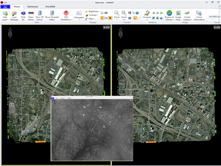
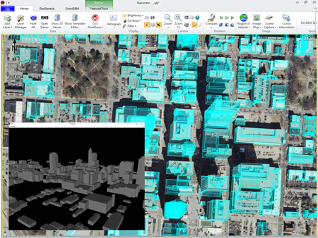
FeatureXTract™ - is a geospatial 3D site-modeling system composed of both automated and semi-automated tools. These tools allow you to rapidly extract 3D buildings and related features from aerial and satellite imagery. FeatureXTract employs a simple split-screen interface eliminating the need for active stereo displays in 3D feature extraction. Using FeatureXTract you can quickly extract precise 3D site models (even on a laptop) and export them for use in a variety of applications (e.g., digital terrain database generation). With FeatureXTract, building a complex urban environment is simple, rapid, and most importantly accurate.
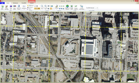
GeoGenesis® - Serving as a pre-processing application, GeoGenesis provides imagery product support and content generation tools giving you complete control over your data. Using GeoGenesis you can rapidly orthorectify aerial and satellite imagery one at a time or in batch mode. In addition, GeoGenesis provides you the ability to perform bundle adjustment on multiple images assisted by automated tie point selection between overlapping images. GeoGenesis includes pan-sharpening capabilities to fuse high-resolution panchromatic imagery with lower resolution color imagery. The GeoGenesis mosaicking capabilities allow you to combine multiple images into a single orthomosaic, and our radiometric balancing capabilities help eliminate any visible seams. Geared for production applications, GeoGenesis is the tool of choice for your imagery processing and production needs.
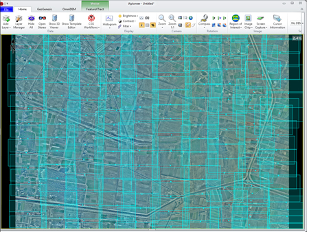
OmniDEM® - If you need accurate and up-to-date digital terrain elevation data, OmniDEM is your solution. Digital Elevation Models (DEMs) are essential to a variety of geospatial production applications, such as GIS, digital terrain database generation, orthorectification, and watershed analysis. OmniDEM provides you the ability to efficiently extract accurate elevation models from stereoscopic imagery as well as full editing capability to refine existing DEMs. OmniDEM's easy to use interface unlocks the secret to generating accurate DEMs from overlapping satellite and aerial imagery.


|